

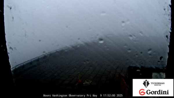
 Mt Washington Wx CAM

Weather 101
This is the start of my "Weather 101" page. This is meant to be an educational page and I will continue to update this page with relevant information. Weather affects most activities we undertake, whether it is driving to see the grandparents, flying to Africa, running a race, or watching a football game. Weather affects them all. In our business we are considered an agricultural business and the heat, humidity, rain, hail, all affect the outcome of crops and what you eat each day. And weather can directly affect the safety of your family! Stay tuned for new updates as time allows.
Clouds
A cloud is a visible collection of minute particle matter, such as water droplets and/or ice crystals, in the free air. A cloud forms in the atmosphere as a result of condensation of water vapor. Condensation nuclei, such as in smoke or dust particles, form a surface upon which water vapor can condense. There are four primary classifications for clouds: cumulus, stratus, cirrus and nimbus. It's easy to tell the different types of clouds apart from one another – just look at the shape! Cumulus clouds are big, puffer shapes that appear to be giant marshmallows; cirrus clouds are very thin and wispy; stratus clouds appear layered on top of one another; and nimbus clouds are dark and heavy in appearance, usually indicative of an impending rain. Clouds can also be classified as a hybrid between two types, like nimbostratus, or by the height of the cloud itself. For example, there are low-level clouds, mid-level clouds and high-level clouds. Measurement starts at the base of the cloud formation.
- Types of Clouds
- Picture Presentation of Cloud Types (PDF)
- Introduction to Cloud Types
- The Formation of Clouds
Dry Line
A dry line (also called dew point line, or Marfa front) is an imaginary line across a continent that separates moist air from an eastern body of water and dry desert air from the west. One of the most prominent examples of such a separation occurs in central North America, especially Texas, Oklahoma, and Kansas, where the moist air from the Gulf of Mexico meets dry air from the desert south-western states. The dry line is an important factor in severe weather frequency in the Great Plains of North America. It typically lies north-south across the High Plains states in the warm sector of an extratropical cyclone and stretches into the Canadian Prairies during the spring and early summer. The dry line is also important for severe convective storms in other regions of the world, such as northern India.
Flooding
A flood is high water flow or an overflow of rivers or streams from their natural or artificial banks, inundating adjacent low lying areas. A Flood Plain is level land that may be submerged by flood waters. Flash Floods are a flood that rises and falls quite rapidly with little or no advance warning, usually as the result of intense rainfall over a relatively small area. Flash floods can be caused by situations such as a sudden excessive rainfall, the failure of a dam, or the thaw of an ice jam. Flooding occurs after natural disasters, like hurricanes, tornadoes and tsunamis, and the resulting water can be devastating in more than one way. Aside from the obvious risk of drowning in deep, fast moving flood water, mold is also a very real danger – especially for those who have existing respiratory problems. Additionally, flood water is often contaminated with harmful chemicals and other pollutants that it carries with it, which makes it unsafe to touch or consume. It's very important to evacuate the area if there is a flood warning, and stay on high ground until the water is under control.
- How to Act in the Event of a Flood
- Causes of Flooding
- Impact of Floods
- Map of Current Global Flooding
Hurricanes
A Hurricane is the name for a tropical cyclone with sustained winds of 74 miles per hour (65 knots) or greater in the North Atlantic Ocean, Caribbean Sea, Gulf of Mexico, and in the eastern North Pacific Ocean. This same tropical cyclone is known as a typhoon in the western Pacific and a cyclone in the Indian Ocean. Living in a Hurricane Zone, I am immensely familiar with their power and destruction. Having lived through hurricanes Ethel, Camille, Fredric, Elena, Georges, Katrina, Issac, and several other named, storms, I feel comfortable talking about the might and destruction these massive storms bring. A hurricane is a very powerful type of storm, with spiraling winds, that carries water with it. Although hurricanes primarily stay over the ocean, they do come on land, as well. When this happens, they can wreck entire communities with their strong winds and subsequent flood waters. The wind in a hurricane travels inward and in an upward direction; this combination of direction and strength is what enables a hurricane to rip roofs off of houses. A hurricane will always start over the ocean, and the temperature of the water has to be 80 degrees Fahrenheit or warmer for this to happen. They are categorized on a special scale from 1-5, and there are six stages of a hurricane: tropical wave, tropical disturbance, tropical cyclone, tropical depression, tropical storm, and finally, hurricane. 1961 was the last time two Category 5 hurricanes formed in the same year. 1960 was the last time two Category 5 hurricanes formed and eventually made U.S. land fall. 2005 has now matched that with Katrina and now Rita.
- National Hurricane Center
- What are Hurricanes?
- An Explanation of Hurricanes and Their Relation to the Equator
- Hurricane Fact Sheet
Thunderstorms
A Thunderstorm is produced by a cumulonimbus cloud, it is a microscale event of relatively short duration characterized by thunder, lightning, gusty surface winds, turbulence, hail, icing, precipitation, moderate to extreme up and downdrafts, and under the most severe conditions, tornadoes. The majority of thunderstorms are the result of a cold front. However, storms can also be associated with other types of weather fronts, as well. Most of us are familiar with thunderstorms – they're a very common weather phenomenon. But do you know how to stay safe in a storm, whether you're caught outside, driving with your parents, or just sitting inside your home? Staying away from metal objects is one of the most important things to remember in a thunderstorm that also contains lightning. Additionally, if you're at home during a storm, make sure you don't take a shower or a bath until the storm blows over.
- Classification of Thunderstorms
- Introduction to Thunderstorms
- Stages, Types and Hazards of Thunderstorms
- Understanding Thunderstorms and Lightning (PDF)
Tornadoes
A Tornado is a violently rotating column of air in contact with and extending between a convective cloud and the surface of the earth. It is the most destructive of all storm-scale atmospheric phenomena. They can occur anywhere in the world given the right conditions, but are most frequent in the United States in an area bounded by the Rockies on the west and the Appalachians in the east. Tornadoes are a type of very powerful storm that can develop out of a thunderstorm. They occur as an eastward moving cold front approaches. Although some tornadoes occur without causing very much damage, they can turn into extremely violent storms very quickly – the wind speed in a tornado can reach all the way up to 250 miles per hour. In fact, some tornadoes move even faster than that! To put this into perspective, that's almost double the speed that a typical family vehicle can achieve. There are three classifications of tornadoes: weak tornadoes, strong tornadoes, and violent tornadoes. A geographic corridor in the United States which stretches north from Texas to Nebraska and Iowa. In terms of sheer numbers, this section of the United States receives more tornadoes than any other. There is a secondary "Tornado Alley" in the Southern U.S. known as "Dixie Alley". Smith County, Mississippi has had more tornadoes than any other county in the United States.
- Facts and Myths about Tornadoes
- Basic Explanation and More Resources on Tornadoes
- How to Stay Safe During a Tornado
- How to Stay Prepared for a Tornado (PDF)
Space Weather
Space weather is the concept of changing environmental conditions in near-Earth space or the space from the Sun's atmosphere to the Earth's atmosphere. It is distinct from the concept of weather within the Earth's planetary atmosphere (troposphere and stratosphere). Space weather is the description of changes in the ambient plasma, magnetic fields, radiation and other matter in space. Much of space weather is driven by energy carried through interplanetary space by the solar wind from regions near the surface of the Sun and the Sun's atmosphere (chromosphere and corona). The term space weather is sometimes used to refer to changes in interplanetary (and occasionally interstellar) space. Space weather has two focal points: scientific research and applications. The term space weather was not used until the 1990s. Prior to that time, activities now known as space weather were considered to be part of physics or aeronomy or space exploration.When the magnetic fields, radiation levels, and orbiting matter that lies in between the Earth's atmosphere and the Sun's atmosphere experience changes, the resulting phenomenon is called space weather. There are three different types of storms that occur in space: geomagnetic storms, solar radiation storms, and radio blackouts. Each type of space storm is rated on its own scale. For example, geomagnetic storms are rated on a scale from G1-G5, with G5 being the most severe. On the Earth, severe space weather conditions can cause blackouts, interfere with satellites, and cause migratory problems in animals.
- N5PA Space Weather Site
- spaceweather.com
- 3-Day Forecast of Solar and Geophysical Activity
- Space Weather Enthusiasts
- Today's Space Weather
- Real-Time Solar Wind
- Space Weather Outlooks
- Space Weather Bulletins
- Space Weather Alerts and Warnings
- Solar and Heliospheric Observatory (SOHO)
- The Very Latest SOHO Images
- Space Weather Resources for Further Learning
- Animations, Data and Resources on Current Space Weather
- What is Space Weather?
Rainbows
A rainbow is an optical and meteorological phenomenon that is caused by reflection of light in water droplets in the Earth's atmosphere, resulting in a spectrum of light appearing in the sky. It takes the form of a multicolored arc. Rainbows caused by sunlight always appear in the section of sky directly opposite the sun. In a "primary rainbow", the arc shows red on the outer part and violet on the inner side. This rainbow is caused by light being refracted while entering a droplet of water, then reflected inside on the back of the droplet and refracted again when leaving it. In a double rainbow, a second arc is seen outside the primary arc, and has the order of its colors reversed, red facing toward the other one, in both rainbows. This second rainbow is caused by light reflecting twice inside water droplets. The seven colors that we commonly associate with rainbows are as follows: red, orange, yellow, green, blue, indigo and violet. This color sequence is often remembered with the mnemonic device ROY-G-BIV. A rainbow spans a continuous spectrum of colors; the distinct bands are an artifact of human color vision. In Roy G. Biv, the colors are arranged in the order of decreasing wavelengths, with red being 650 nm and violet being about 400 nm. Other variations are ROYGBIV and VIBGYOR. In Classical Antiquity, Aristotle claimed there was a fundamental scale of seven basic colors. In the Renaissance, several artists tried to establish a new sequence of up to seven primary colors from which all other colors could be mixed. In line with this artistic tradition, Newton divided his color circle, which he constructed to explain additive color mixing, into seven colors. His color sequence including the tertiary color indigo is kept alive today by the Roy G. Biv mnemonic. Originally he used only five colors, but later he added orange and indigo, in order to match the number of musical notes in the major scale. The Munsell color system, the first formal color notation system (1905), names only five "principal hues": red, yellow, green, blue, and purple (although note that Munsell's purple is not a spectral hue). Another traditional mnemonic device has been to turn the initial letters of seven spectral colors into a sentence. In Britain the most common is "Richard Of York Gave Battle In Vain." The mnemonic is said to refer to the defeat and death of Richard, Duke of York at the Battle of Wakefield. In order to avoid reference to this defeat, people from Yorkshire developed the alternative "Rowntrees Of York Gave Best In Value." Alternatively, the biblically inspired "Read Out Your Good Book In Verse," or the more anarchic "Rinse Out Your Granny's Boots In Vinegar," may be used.
- Science Behind Rainbows
- Introduction to Primary and Secondary Rainbows
- How Rainbows Work
- Rainbow Lesson Plan
Weather Forecasting
Weather forecasting is the application of science and technology to predict the state of the atmosphere for a given location. Human beings have attempted to predict the weather informally for millennia, and formally since the nineteenth century. Weather forecasts are made by collecting quantitative data about the current state of the atmosphere and using scientific understanding of atmospheric processes to project how the atmosphere will evolve.
Once an all-human endeavor based mainly upon changes in barometric pressure, current weather conditions, and sky condition, weather forecasting now relies on computer-based models that take many atmospheric factors into account. Human input is still required to pick the best possible forecast model to base the forecast upon, which involves pattern recognition skills, teleconnections, knowledge of model performance, and knowledge of model biases. The chaotic nature of the atmosphere, the massive computational power required to solve the equations that describe the atmosphere, error involved in measuring the initial conditions, and an incomplete understanding of atmospheric processes mean that forecasts become less accurate as the difference in current time and the time for which the forecast is being made (the range of the forecast) increases. The use of ensembles and model consensus help narrow the error and pick the most likely outcome.
There are a variety of end uses to weather forecasts. Weather warnings are important forecasts because they are used to protect life and property. Forecasts based on temperature and precipitation are important to agriculture, and therefore to traders within commodity markets. Temperature forecasts are used by utility companies to estimate demand over coming days. On an everyday basis, people use weather forecasts to determine what to wear on a given day. Since outdoor activities are severely curtailed by heavy rain, snow and the wind chill, forecasts can be used to plan activities around these events, and to plan ahead and survive them.
Weather forecasting is a science that allows us to predict weather conditions in advance. For example, we can detect cold fronts before they start to advance. Weather forecasting is a very useful application in that it gives us the opportunity to react to natural disasters before they strike, which can save many lives. Additionally, we can also issue weather alerts based on these scientific reports. There are five primary methods of predicting the weather: the persistence method, trends method, analog method, climatology, and numerical weather prediction.
- Methods of Predicting Weather
- Severe Weather Forecasting Activity
- How to Forecast Weather without Instruments
- Forecasting Under Pressure Activity for Kids
- Weather Predication Resources and Activity Sheet for Kids (PDF)
- Weather Data and Tools for Kids
Winter Storms
A winter storm is an event in which the varieties of precipitation are formed that only occur at low temperatures, such as snow or sleet, or a rainstorm where ground temperatures are low enough to allow ice to form (i.e. freezing rain). In temperate continental climates, these storms are not necessarily restricted to the winter season, but may occur in the late autumn and early spring as well. Very rarely, they may form in summer, though it would have to be an abnormally cold summer, such as the summer of 1816 in the Northeast United States of America. The Weather Channel has committed, beginning in the 2012-2013 season, to naming winter storms.
Although most of us look forward to playing in the snow, the storms that bring snowfall can turn into a deadly phenomenon pretty quickly. For example, a snowstorm can turn into a blizzard, which is a storm that has very heavy snowfall, freezing winds, and sleet. Ice can form regardless of the severity of the snowstorm that your area is experiencing provided that the outside temperature is low enough. It's very important to stay off the roads during a heavy snow storm to avoid accidents, and you should always make sure that your house is stocked up on non perishable food items that will last you at least several weeks in the event of a debilitating blizzard.
Weather Fronts
A weather front is a boundary separating two masses of air of different densities, and is the principal cause of meteorological phenomena. In surface weather analyses, fronts are depicted using various colored lines and symbols, depending on the type of front. The air masses separated by a front usually differ in temperature and humidity. Cold fronts may feature narrow bands of thunderstorms and severe weather, and may on occasion be preceded by squall lines or dry lines. Warm fronts are usually preceded by stratiform precipitation and fog. The weather usually clears quickly after a front's passage. Some fronts produce no precipitation and little cloudiness, although there is invariably a wind shift.
Cold fronts and occluded fronts generally move from west to east, while warm fronts move poleward. Because of the greater density of air in their wake, cold fronts and cold occlusions move faster than warm fronts and warm occlusions. Mountains and warm bodies of water can slow the movement of fronts. When a front becomes stationary, and the density contrast across the frontal boundary vanishes, the front can degenerate into a line which separates regions of differing wind velocity, known as a shearline. This is most common over the open ocean.
Weather fronts are a key part of analyzing and predicting future weather. A front is the area between two different densities of air. Sometimes, it can be very difficult to identify a weather front from the ground because the boundary between the air masses is not apparent. They're easiest to spot when the air masses on either side differ greatly in density, temperature and humidity, because these differences create a very distinct divide. There are four kinds of weather fronts: cold fronts, warm fronts, stationary fronts, and occluded fronts.
- Explanation of Stationary Fronts
- What is a Weather Front?
- How to Identify Weather Fronts
- Introduction to Weather Fronts
- How to Read Weather Maps